Company News Industry Information

Ecological Hydrological Water Level Monitoring Station Real time Dynamic Monitoring of Water Level Factors

2025-12-11 15:12:10

Background of the Ecological Hydrological Water Level Monitoring Station

Ecological hydrological water level is a core indicator for maintaining watershed ecological balance and ensuring the sustainable use of water resources. Its dynamic changes directly affect wetland conservation, vegetation growth, and the safety of aquatic habitats, while being closely linked to flood control, drought resistance, water resource regulation, and ecological restoration. However, most ecological hydrological monitoring areas (such as rivers, lakes, wetlands, and mountain streams) feature complex terrain and inconvenient transportation. Traditional manual monitoring suffers from limitations including low frequency, data lag, limited coverage, and high labor costs, making it difficult to promptly capture abnormal changes such as sudden water level surges, plummets, or prolonged droughts during low-flow periods. As a result, it fails to provide accurate data support for ecological protection and water resource management. With the increasingly stringent ecological protection regulations and the growing risk of water level fluctuations caused by frequent extreme weather events (e.g., heavy rains, prolonged droughts), there is a significant increase in the demand for real-time, continuous, and accurate water level monitoring in the refined management of watershed ecosystems and the coordinated scheduling of cross-regional water resources. Additionally, tasks such as wetland protection, guaranteed ecological flow of rivers and lakes, and evaluation of ecological restoration effects urgently require systematic water level monitoring data as a basis for decision-making. 


System Overview

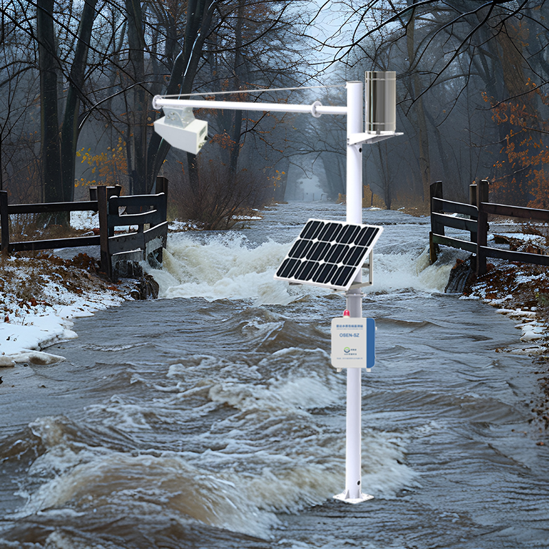
The Hydrology and Water Quality Online Monitoring System integrates sensor technology, data communication technology, and big data analysis technology. It enables continuous real-time monitoring of multiple water-related parameters, including water flow, water level, rainfall, as well as water quality indicators such as dissolved oxygen, pH value, turbidity, and conductivity. Monitoring data is transmitted to the monitoring platform in real-time via the network, ensuring timeliness and accuracy.
Advanced algorithms are used to conduct in-depth analysis of the collected data, generating detailed reports that help users better understand water body change trends, predict potential future issues, and formulate corresponding response strategies. Intelligent real-time monitoring not only reduces the workload and costs of manual monitoring but also improves monitoring efficiency and data accuracy. The system plays a crucial role in water resource management, pollution control, and environmental monitoring, providing strong technical support for achieving sustainable development.


System Features

Power Supply System: Dual-power supply options (AC 220V, storage battery, solar power system, etc.) are available for customization. Flexible switching between commercial power and solar energy is supported.

Reliable Operation: Designed for harsh field environments with low power consumption, high stability, high precision, and unattended operation capabilities.

Protection Measures: Equipped with reliable lightning protection, grounding design, and anti-interference capabilities to ensure stable operation.

Modular & Open Design: Both hardware and software adopt a modular, open architecture, allowing flexible combination and configuration.

Customizable Monitoring Parameters: Monitoring indicators can be selected based on actual needs. The modular design greatly facilitates later equipment debugging and upgrading.

Optional Communication Methods: Communication modes can be chosen according to transmission distance to achieve optimal cost-effectiveness.

Multi-terminal Access: Monitoring data can be queried and statistically analyzed via software clients, PC-based cloud platforms, and mobile WeChat official accounts through the internet.


System Functions

24/7 Real-time Monitoring: Equipped with high-precision sensors, the system real-time displays monitoring data of flow velocity, flow rate, rainfall, and water quality. With fast data update frequency, it promptly reflects changes in various parameters, ensuring data accuracy and reliability.

GPS Positioning System: A built-in GPS module records the real-time location of the equipment and uploads it to the server. Users can view the device’s location marker on the real-time GIS map by logging into the system platform.

Offline Data Transmission & Recovery: When a network interruption is detected, the system automatically stores monitoring data in local storage devices. Once the network is restored, the stored data is automatically uploaded to the server database, ensuring data integrity, continuity, and security even in unstable network conditions.

Over-limit Alarm: Thresholds for monitoring data can be set according to actual requirements. When data exceeds the preset thresholds, the system automatically triggers an alarm and notifies relevant personnel via PC and mobile devices, enabling timely measures to prevent the spread of environmental pollution.

Data Storage & Transmission: The system automatically collects monitoring data in real-time and transmits it to the cloud platform via wireless networks for storage, analysis, and visualization. It provides an intuitive data visualization interface, allowing users to quickly grasp data status and conduct in-depth analysis to support scientific decision-making.


Keyword:

Recommend