ONLINE MONITORING SYSTEM FOR GEOLOGICAL DISASTERS
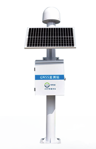
The Global Navigation Satellite System GNSS based displacement monitoring station utilizes advanced positioning technology to detect deformation caused by geological hazards. Through continuous observation, it meticulously records and analyzes spatial data across different time periods, enabling precise calculation of minute shifts in the Earth´s surface or crust. This high precision monitoring capability allows real-time detection of early warning signs, facilitating timely alerts that significantly enhance disaster prevention and response capabilities. Such systems safeguard public safety and property security. Continuous, accurate monitoring plays a vital role in geological hazard prediction and mitigation efforts.
System features
High precision: can achieve millimeter-level or higher precision displacement monitoring to ensure the accuracy of data;
Real-time: the monitoring data is sent to the monitoring center or cloud platform in time to realize real-time monitoring and early warning;
All-day: not limited by weather conditions, can work stably in all kinds of harsh environments;
Automation: can operate stably for a long time without being on duty;
Data collection and analysis: automatically complete data collection, transmission,processing and analysis.
System functions
real-time monitoring
Real-time surface displacement data are obtained, and the occurrence and development trend of geological disasters such as landslide, collapse and subsidence are monitored and analyzed in real time through high-precision monitoring technology.
Timely warning
Through data analysis and model predictions, we can accurately assess the likelihood of geological disasters and provide early warning alerts. When anomalies are detected-such as a significant increase in displacement rate-we immediately generate warnings and notify relevant management personnel via multiple channels (including SMS, emails, mobile apps, etc.). This provides decision-making support for authorities and enables timely implementation of disaster prevention and mitigation measures.
Data analysis and visualization
Real-time collection and processing of surface displacement data, and the transformation of complex data into intuitive images through charts, maps and other visualization tools to help managers better understand and analyze monitoring results.
Multi-terminal access and linkage
Through mobile devices like smartphones and tablets, users can access real-time data for remote monitoring and management. The system also integrates with related platforms such as weather forecasting systems and emergency management systems, enabling data sharing and consolidation to enhance th efficiency and accuracy of geological disaster monitoring. This multi-terminal access and cross-system coordination significantly accelerates emergency response capabilities, providing robust technical support for disaster prevention and mitigation efforts.
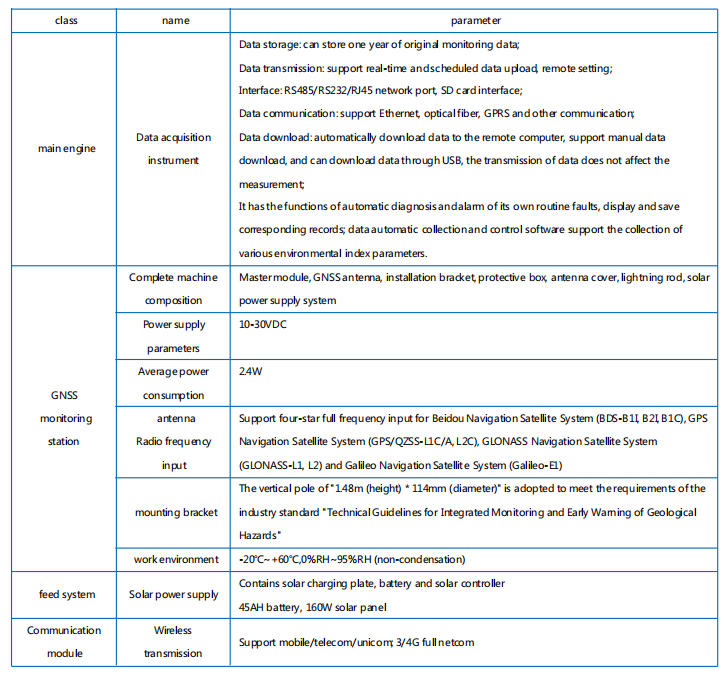
technical parameter