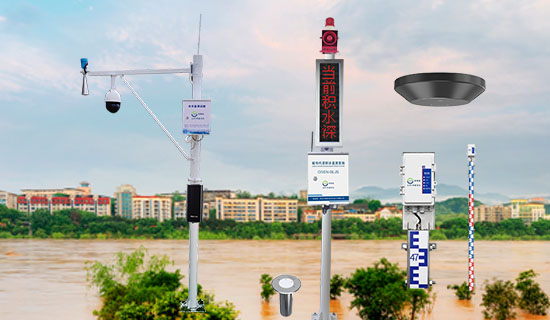
Background overview
Since ancient times, people have never stopped exploring the natural environment, but in most cases, people are still unable to control and change the direction of nature. Haistones can still destroy farmland, earthquakes can still destroy houses, and heavy rain can also cause floods, threatening People´s Daily life and even life and property safety. In the rainy season, the most likely natural disaster to occur is rainstorm and flood disaster, and this disaster threatens the safety of people´s life and property. Summer is the frequent rainstorm season, which is also the main stage of flood disaster, and weather and climate is the main influencing factor.
In recent years, the flood disaster caused by the rainy season and abnormal climate has brought great pressure to the municipal departments. Due to the heavy rainfall, the river backflow, road flooding, traffic jams, bridge building damage, which has brought huge economic and life danger to the relevant units and people. In order to reduce the loss caused by waterlogging, on the one hand, we should strengthen the construction of urban drainage infrastructure; on the other hand, we should fully grasp the urban flood situation, monitor the river level, urban rainfall, water level of tunnel bridge and low-lying sections, and establish the urban flood warning system.
With the influence of urbanization, river, reservoir management become more complex, to realize the fine management of river, reservoir, must use advanced information technology to support, realize the three prevention, water resources, water supply security real-time monitoring, for flood control and disaster relief to provide accurate and timely data information, improve the ability of hydrological monitoring and forecasting accuracy to provide scientific support.
Waterlogging pain points
(1) The rapid development of the urbanization process, highlights the lack of urban flood control and drainage capacity.
(2) In the global warming environment, urban "seeing the sea" has become normal, and waterlogging monitoring and early warning equipment is basically blank.
(3) The lack of urban waterlogging foundation and historical data makes it impossible to start.
(4)It is urgent to solve the problem of urban waterlogging, and customized schemes can be implemented quickly.

system survey
When the flood season comes, it is very important to timely obtain the water level increase data of river reservoirs to carry out flood control and flood fighting work. A large number of river reservoirs are distributed in areas far away from the city, and scattered, especially in the emergency flood control stage, if only rely on traditional manpower inspection to obtain river water level data will consume a lot of manpower and material resources.
Osn, water rainfall regime online monitoring and early warning system, in order to realize the reservoir (river) water rainfall regime information "total elements, full range, full coverage" automatic measurement as the goal, have reservoir water level, rainfall, field images, video and other hydrological information collection, transmission, processing and early warning, effectively improve the information of timeliness and accuracy, to ensure the safe operation of the reservoir and auxiliary basin flood control joint scheduling decision to provide data security, making the possible affected areas to take timely measures to minimize personnel and property losses.
Water rain online monitoring system is an automatic hydrological online monitoring system based on microwave technology, which can measure the water level and rainfall in the channel simultaneously. It adopts advanced K-band plane radar technology to measure the water level and rainfall by non-contact way, calculates and outputs the real-time section flow and cumulative flow according to the built-in software algorithm; can be used for non-contact flow measurement in river channel, irrigation channel, underground drainage network, flood control and early warning; the product has the characteristics of low power consumption, small size, high reliability and convenient maintenance; the measurement process is not affected by temperature, sediment, river pollutants, floating objects on water surface and other factors.
Water rainfall regime on-line monitoring and early warning system is mainly composed of rainfall regime telemetry station, water level station, automatic flow station and video and image monitoring stations, at the same time establish standard, unified monitoring platform, information collection, transmission, analysis and early warning of multi-function, implements the early warning information timely and accurately upload, standardize project management, eliminate safety hidden trouble, enhance the level of informatization, ensure the safe operation of the reservoir (river).
System construction
Construction target
1) Realize the real-time collection of water and rain situation information, as well as the water level flow rate and rainfall warning notice, to ensure the high efficiency, timeliness, accuracy and adequacy of the system information.
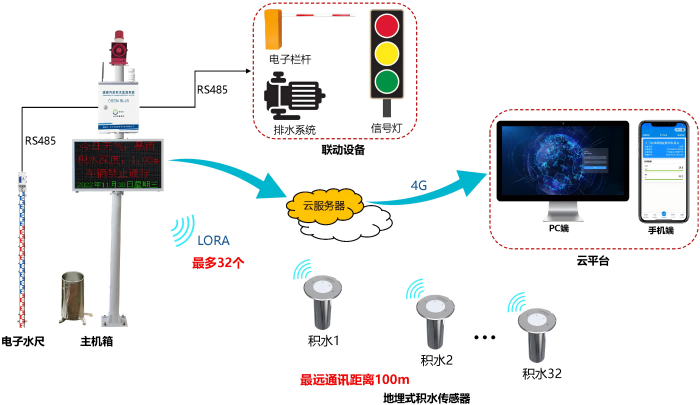
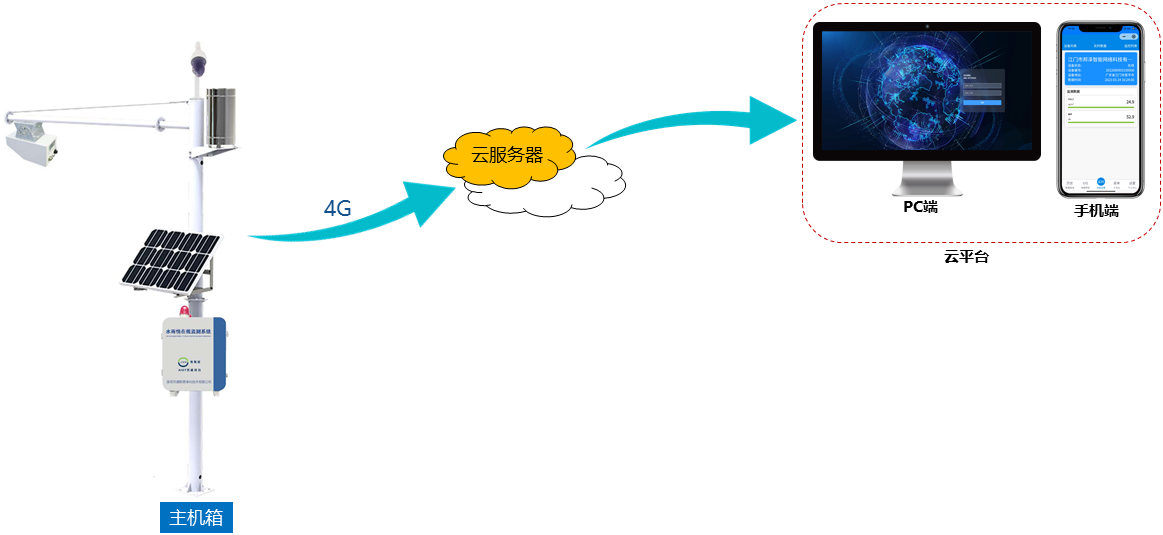
2) All data of observation points are directly transmitted to the Water and rain Automatic Monitoring system through the wireless network, which displays the water and rain information, water level and warning status of the test point. When the alarm occurs, the system can send the alarm signal automatically, such as the message, and send the alarm message to the designated personnel of the relevant departments.
3) The system development should adhere to the principle of advanced practicality, stability and reliability, and have good expansibility, compatibility and openness, so as to provide normative interfaces for the expansion and upgrading of the system in the later stage and provide data sharing services to other related platform systems.
4) The system can access the video camera and monitor the live video screen in real time.(apolegamy)
Construction content
1、 Remote monitoring of water level, rainfall and other data, and timely reporting of flood situation information
① Remote collection of water level meter, flow velocity, rain gauge and other data;
② According to the standard hydrology / water resources regulations, automatically report to the provincial, municipal and county water conservancy platform through 4G / 5G;
③ Water quality monitoring can be expanded.
2、 Image / video surveillance, can measuring point data
① Visualized management of key locations in the city to facilitate remote inspection in flood season or danger occurs;
② Video surveillance is configured on demand to meet the needs of real-time on-site video viewing;
③ Image / video can overlay the measurement point position, water level, flow rate, precipitation, water accumulation and other data to realize visual remote monitoring.
3、 Over the limit of the automatic alarm, timely early warning of the flood situation
① Water level, flow rate, rainfall, water exceed the limit, the system automatically alarm, timely report the flood information;
② Automatically push the alarm information to the responsible person´s mobile phone.
Construction effect
1、Data monitoring function, online real-time monitoring of rainfall, water level, water and rain situation, temperature and humidity, mountain displacement and other target data, to complete the target data measurement.
2、Abnormal alarm function, monitoring factor threshold setting, and data alarm in the danger value.
3、Wireless early warning broadcast, the system remote control danger information through the wireless network release, on-site led screen, broadcast notification.
4、Remote and real-time monitoring of images and videos, GIS system, decentralized monitoring points and unified management.
5、Pc, mobile phone, app and efficient management.
6、Data reception, analysis and processing, control command issuance, warning information and early warning information to remind the relevant command personnel to prepare for rescue and relief work.
system composition
The construction of the online monitoring and early warning system, including the construction of the water level, flow rate, rainfall, water, weather and other information collection equipment, as well as the information receiving, display and application system of the monitoring center. The on-site measuring point information collection and transmission equipment completes the real-time collection, basic processing and analysis (such as alert state) and display of water level and rainfall information, and is responsible for the wireless transmission of data to the monitoring center, receiving, display and data storage, analysis, processing and early warning through the software.


system parameter
|
Water and rain situation online monitoring system
|
|
Overall performance
|
Overall performance
|
Embedded, modular structure design, small size, reliable performance
|
|
real-time data
|
Display the monitoring values in real time
|
|
signal output
|
4G full netcom, RS485
|
|
remote access
|
Support for the remote access mode
|
|
power supply mode
|
Us AC220V, solar power supply system
|
|
Local storage
|
Supports the local SD card storage
|
|
display mode
|
7-inch touch HD display, personalized LED screen
PC terminal platform, mobile terminal APP / public account
|
|
data transmission
|
Data transmission complies with the external communication standard issued by the State Environmental Protection Administration, the 212 protocol
|
|
work environment
|
-20℃ ~70℃, 0 ~ 95% RH (non-condensation)
|
|
remote monitor and control
|
Optional ball machine camera, support cloud head control, real-time picture viewing
|
|
way to install
|
Standing rod type
|
|
Upload frequency
|
1min
|
|
Rainfall sensor
|
measuring range
|
0-4mm / min (rainfall intensity)
|
|
accuracy
|
± 4% (indoor static test, rain intensity is 2mm / min)
|
|
resolution ratio
|
0.2mm(6.28ml)
|
|
Water bearing caliber
|
φ114mm
|
|
power supply mode
|
DC5V/DC12V/DC24V
|
|
output signal
|
Pulse (pulse signal)
|
|
wire length
|
Standard with 5m (the line length can be customized according to the actual requirements of customers)
|
|
work environment
|
Temperature: 0-60℃ Humidity: 0-100% RH
|
|
levels of protection
|
IP65
|
|
Product weight
|
450g
|
|
Radar water flow meter
|
Speed measurement range
|
0.1~20m/s
|
|
rate accuracy
|
±1%FS
|
|
Speed resolution
|
0.01m/s
|
|
Range range
|
0.4~40m
|
|
ranging accuracy
|
±1cm
|
|
range resolution
|
1mm
|
|
Antenna style
|
Flow rate: 14x32?water level: 11x11?
|
|
interval
|
1~5000min
|
|
service voltage
|
The DC flow varies from 7 to 28 V
|
|
Current (12V power supply)
|
Less than 240 mA and less than 1 mA
|
|
working temperature
|
-40°~85°
|
|
classification of waterproof
|
IP68
|
|
emission frequency
|
24.000~24.250GHz
|
|
communication interface
|
RS-485
|
|
protocol
|
MODBUS-RTU / Custom protocol
|
|
Buried water accumulation sensor
|
power supply mode
|
Built-in battery power supply (3.6V lithium sub-battery)
|
|
duration of flight
|
No water accumulation, it can work continuously for 5 years
|
|
Water level range
|
≤1.5m
|
|
Water level error
|
1cm
|
|
resolution ratio
|
1mm
|
|
Case material
|
304 Stainless steel
|
|
levels of protection
|
IP68
|
|
output signal
|
LORA
|
|
way to install
|
Use buried installation
|
|
Electronic water ruler
|
operational principle
|
The weak electrical conductivity of the water
|
|
Case material
|
stainless steel
|
|
power supply mode
|
D C 10-30V
|
|
accuracy
|
.51cm, 0cm (full range equal accuracy)
|
|
Unit section specifications
|
50cm、80cm
|
|
gage length
|
50cm and 80cm were randomly combined without section number limit
|
|
CI
|
R S485,4G, 4-20 mA, 0-5V, 0-10V are optional
|
|
work pattern
|
Air high mode, water depth mode, tilt mode three optional
|
|
control switch
|
R S485,4G, default belt relay output, can be associated with alarm items output or used for water level upper and lower limit control
|
|
Mancover sensor
|
supply electricity
|
Lithium sub-battery Supply (19000 mAh)
|
|
Working temperature and humidity
|
-40℃ ~ + 70℃, 0% RH ~ 95% RH (non-condensation)
|
|
gaging spindle
|
Z axle
|
|
measuring range
|
±90°
|
|
resolution ratio
|
0.1°
|
|
Alarm threshold
|
The 0-90° can be set up
|
|
Water level detection range
|
2m
|
|
resolution ratio
|
0.1cm
|
|
Water level detection accuracy
|
±3% FS
|
|
output signal
|
NB-IoT
|
|
stand-by time
|
More than 5 years
|
|
Upload data intervals
|
360min (default), 5-1440min is available
|
|
antenna
|
built-in
|
|
levels of protection
|
IP68
|
|
Ultrasonic weather sensor
|
measuring range
|
Wind speed: 0-45 m/s
Wind direction: 0-359°
temperature-50?100℃
Humidity: 0-100% RH
Air pressure: 10-1100 hpa
|
|
accuracy
|
Wind speed: low wind speed: ± 0.5 m/s high wind speed: ± 1 m/s
Wind direction: low wind speed: ± 5° high wind speed: ± 3°
temperature:±0.5℃
Humidity: ± 3% RH
Air pressure: ± 0.3 hpa
|
|
resolution ratio
|
Wind speed: 0.1 m/s
Wind direction: 1°
temperature:0.1℃
Humidity: 0.1% RH
Air pressure: 0.1 hpa
|
|
material quality
|
engineering plastic
|
|
power supply mode
|
DC12V
|
|
output signal
|
RS485 (Baud rate 9600 standard MODBUS protocol)
|
|
wire length
|
Standard 2.5m (line length can be customized according to actual customer requirements)
|
|
work environment
|
Temperature: -40-70℃ Humidity: 100% RH
|
|
levels of protection
|
IP65
|
|
Appearance size
|
0.6KGφ90*140mm
|
|
Product power consumption
|
0.2W
|
|
camera
|
AI ballhead camera
|
Built-in GPU chip, support deep learning algorithm, effectively improve the detection accuracy
Support the water ruler filter identification, effectively identify the target water ruler in the scene
Support simple water ruler calibration, customers can also be professional scene adaptation
Support the splicing line drawing, the OSD can stack to display the actual water level values
Support for construction vehicle testing
Support the docking of GS-12V-W2
Support for 32 x optical zoom, 16 x digital zoom
With a 4-megapixel 1 / 2.8-inch CMOS sensor
Support starlight level ultra-low illumination
support H.265 Ending, realize ultra-low code stream transmission
Built-in 100 meters white light fill light
Continuous rotation of 360°horizontal direction, vertical direction-20°~90°automatic flip 180°after continuous monitoring, no monitoring blind area
Support for 300 preset bits, 8 cruise paths, and 5 patrol paths
Support 1 audio input and 1 audio output
Built-in 2 alarm input and 1 alarm output, support alarm linkage function
Support IP66 protection level, 6000V lightning protection, surge and wave protection
Support for DC12V / 5A (-10%~ + 10%) power supply
The maximum power consumption of the equipment is 30.8W, the amount of power in the dormant mode is 3.5W, and the still image is 4.5W;
Support OSD power display, real-time perception of power information
Support 4G full netcom
Support timing, time period, SMS, movement control four sleep modes
|
|
Solar energy control system
|
storage battery
|
402.5AH
|
|
solar panel
|
800W
|
|
component
|
Including battery buried box, solar panel installation rod, bracket
|
|
function
|
Support environmental monitoring equipment and customers plus gun machine, ball machine power supply, rainy day endurance time of 5 days;
|
System advantage
1、 Using wireless transmission mode, close communication distance, high transmission efficiency, and is not limited by environmental conditions, can meet the needs of various complex applications;
2、 Simple equipment, easy to install, low maintenance cost;
3、 Strong anti-interference ability, strong resistance and strong wind resistance ability;
4、 Easy to deploy, moderate price, automated operation, without the need for manual duty;
5、 Easy for remote monitoring.
Product design principles
Product design with advanced technology, practical system, reasonable structure, the mainstream product, low cost, low maintenance as the basic principles, the system architecture design.
(1) Advanced technology: the system selection and the configuration of hardware and software equipment are in line with the trend of high and new technology, and the real-time data collection and transmission of key pollution sources adopt the technologies and products widely used in domestic and foreign engineering construction. Under the premise of meeting the function, the system design has advanced nature, and in a certain period of time.
(2) Structure rationality: the advanced and mature technical architecture is stable and reliable, so that the online monitoring system can operate safely and smoothly, effectively eliminate the bottleneck caused by the online monitoring system, and select appropriate equipment to ensure the good scalability of each subsystem. Only a stable and reliable online monitoring system can ensure the normal operation of each equipment; only good pollution source data sharing, real-time fault repair and data backup.
(3) Economy: on the premise of meeting customer function and performance requirements, reduce the cost of system construction, and adopt economic and practical technology and equipment.
(4) Practicality: In equipment selection, according to the actual situation of the online monitoring project, the products with the optimal performance ratio and price ratio and expansion ability.
(5) Maintainability: the designed online monitoring system and the pollution source data collector used are simple, practical, easy to operate and easy to maintain. The easy operation and easy maintenance of the online monitoring system are the conditions for non-computer professionals to use the system well. And the online monitoring system should be able to get timely and rapid maintenance in case of failure.
(6) Manageability: online monitoring of front-end field equipment, each subsystem is centralized in the unified control of the center, to implement the control and setting of all remote equipment, to ensure that the system is efficient, orderly and reliable to play its management function.
(7) Safety: take necessary safety protection measures for the online monitoring system to prevent lightning strike, overload, power failure and man-made damage, with a high degree of security and confidentiality.
(8)Normative: the control protocol, coding and decoding protocol, interface protocol and transmission protocol shall comply with the relevant national standards, industry standards and the technical specifications issued by the Ministry of Environmental Protection.
Water and rain situation monitoring cloud platform
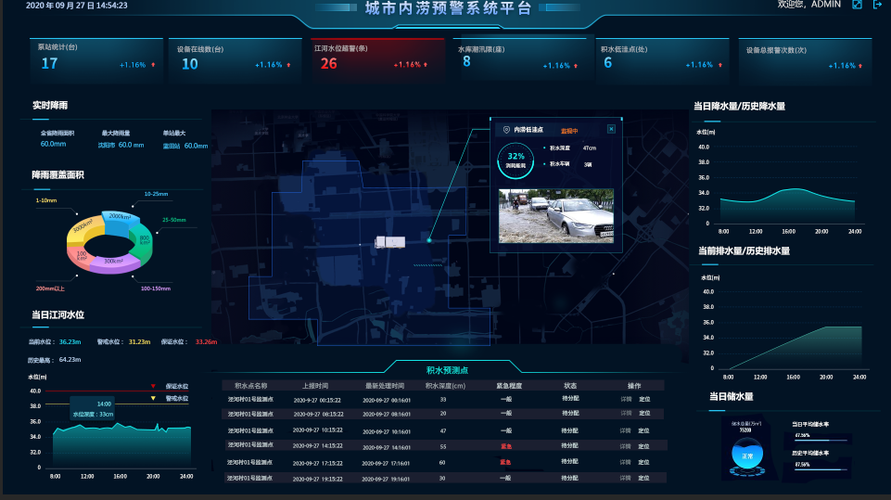
According to the needs of urban waterlogging construction, Osn has designed and built a smart platform closely combining pre-flood, mid-flood, post-flood and operation and maintenance. Pre-flood intelligent deduction, materials in advance control, effectively avoid the risk of urban waterlogging. Combined with intelligent deduction, real-time monitoring of equipment and flexible emergency command have become an important part of urban waterlogging. After the flood disaster recovery summary and report and information disclosure, operation and maintenance management equipment status and maintenance, to ensure the use of the flood season, formed a complete urban emergency system, to achieve rapid disposal and timely report, and close cooperation with meteorological, water conservancy, transportation, municipal and other departments to build a digital intelligent early warning platform.
The Osn water and rain monitoring cloud platform (hereinafter referred to as the cloud platform) conducts real-time monitoring of water and rain data through on-site equipment, and applies the monitoring data for quality control, analysis and application in the software system. Data details can be displayed in multiple ways, intelligent analysis and comparison, generate analysis reports; combined with big data analysis model, realize pollution traceability and trend prediction, and a large data supervision screen to visually present the dynamic data changes and fully meet the monitoring needs of regulatory units.
The platform is equipped with PC and mobile terminals (Android APP, wechat public account and small program). Customers can actively obtain data through the open API interface of our platform, and also support third-party platforms.
After logging in to the account, users can view the real-time online status of the monitoring device, real-time data, historical data and data curve analysis diagram of the monitoring device online. GIS map display, video monitoring, historical data query, data comparison, pollution calendar, transmission statistics, equipment ranking, data report export, equipment status, equipment self-inspection, equipment management, user management, data report generation, excessive alarm push, data screen and other functions.


